

Wednesday features a mix of sun, clouds, and morning showers in the East Coast metro area, with periods of storms developing in the afternoon. The Gulf Coast will be sunny in the morning, but storms will return in the afternoon. The Keys will see clouds, showers, and storms. Coastal flooding is likely near high tides, especially along the Atlantic coast and in the Keys. A high risk of dangerous rip currents continues at the Atlantic beaches. Highs on Wednesday will be mostly in the upper-80s in the East Coast metro area and the Keys and near 90 degrees along the Gulf Coast.
Thursday will bring morning showers and afternoon storms in the East Coast metro area, while the Gulf Coast will see a mix of sun, clouds, and mainly afternoon showers and storms. Look for clouds, showers, and storms in the Keys. Expect an elevated risk of dangerous rip currents at the Atlantic beaches. Thursday’s highs will be mostly in the upper-80s.
Friday will feature plenty of clouds, morning showers, and afternoon and evening storms in the East Coast metro area. The Gulf Coast will see morning showers and plenty of storms in the afternoon and evening. The Keys will see clouds, showers, and storms again. Friday’s highs will be mostly in the mid-80s.
Saturday will see a mix of sun, clouds, showers, and some storms in spots in the East Coast metro area. The Gulf Coast will see plenty of clouds and a few afternoon storms. The Keys will see clouds, showers, and storms again. Saturday’s highs will be mostly in the mid-80s.

Sunday’s forecast calls for plenty of sun around South Florida, but the east coast metro area will also see a few clouds and showers at times as a weak front moves through. Highs on Sunday will be mostly in the mid-80s.
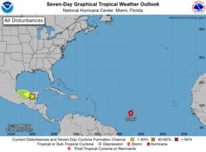 In the tropics, we’re keeping an eye on Tropical Storm Jerry, which formed in the central Atlantic Tuesday morning. Jerry is forecast to strengthen into a hurricane before it makes its closest approach to the northern Leeward Islands. After that, a turn to the north is expected to keep Jerry well east of us. Elsewhere, the area of low pressure in the Bay of Campeche has a low chance of developing before reaching the Mexican coast — but it will bring heavy rain to the region.
Disclaimer
Artificial Intelligence Disclosure & Legal Disclaimer
AI Content Policy.
To provide our readers with timely and comprehensive coverage, South Florida Reporter uses artificial intelligence (AI) to assist in producing certain articles and visual content.
Articles: AI may be used to assist in research, structural drafting, or data analysis. All AI-assisted text is reviewed and edited by our team to ensure accuracy and adherence to our editorial standards.
Images: Any imagery generated or significantly altered by AI is clearly marked with a disclaimer or watermark to distinguish it from traditional photography or editorial illustrations.
General Disclaimer
The information contained in South Florida Reporter is for general information purposes only.
South Florida Reporter assumes no responsibility for errors or omissions in the contents of the Service. In no event shall South Florida Reporter be liable for any special, direct, indirect, consequential, or incidental damages or any damages whatsoever, whether in an action of contract, negligence or other tort, arising out of or in connection with the use of the Service or the contents of the Service.
The Company reserves the right to make additions, deletions, or modifications to the contents of the Service at any time without prior notice. The Company does not warrant that the Service is free of viruses or other harmful components.


")
")
")


")

