

Saturday features more clouds than sun with showers and storms on a gusty breeze in the East Coast metro area. Heavy rain and localized flooding are possible. The Gulf Coast will be mostly sunny with a brisk breeze and afternoon showers and storms. The Keys will see a mix of sun, clouds, and a few showers. A high risk of dangerous rip currents remains at the Atlantic beaches through Sunday morning, and minor coastal flooding is possible along the Atlantic coast and the Keys near high tides. Highs on Saturday will be in the mid-80s along the Atlantic coast and the upper 80s elsewhere in South Florida.
Sunday will bring mostly sunny skies around South Florida, but look for periods of showers and storms as well on the mainland. Sunday’s highs will be in the upper 80s.
Monday will feature some morning storms and plenty of afternoon showers in the East Coast metro area, while the Gulf Coast will see a mix of sun, clouds, and showers in the morning and periods of storms in the afternoon. Look for mostly sunny skies in the Keys. Monday’s highs will be in the upper 80s.
Tuesday will see a mix of sun, clouds, showers, and storms in the East Coast metro area. The Gulf Coast will be mostly sunny with some afternoon storms, while the Keys will see a mix of sun and clouds. Tuesday’s highs will be in the upper 80s.

Wednesday’s forecast calls for mostly sunny skies with periods of showers and storms. Highs on Wednesday will be in the upper 80s in the East Coast metro area and the Keys and near 90 degrees along the Gulf Coast.
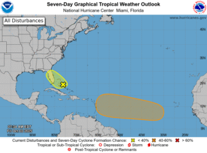 In the tropics, we’re watching a low that has formed in the central Bahamas, which will hang around the Bahamas and South Florida for a couple of days. While it has a low chance of development, it will increase our chances of heavy rain and localized flooding. Elsewhere, a wave merging from the African coast will eventually merge with another feature in the eastern Atlantic and move generally to the west-northwest. It has a medium chance of developing during the next several days.
Disclaimer
Artificial Intelligence Disclosure & Legal Disclaimer
AI Content Policy.
To provide our readers with timely and comprehensive coverage, South Florida Reporter uses artificial intelligence (AI) to assist in producing certain articles and visual content.
Articles: AI may be used to assist in research, structural drafting, or data analysis. All AI-assisted text is reviewed and edited by our team to ensure accuracy and adherence to our editorial standards.
Images: Any imagery generated or significantly altered by AI is clearly marked with a disclaimer or watermark to distinguish it from traditional photography or editorial illustrations.
General Disclaimer
The information contained in South Florida Reporter is for general information purposes only.
South Florida Reporter assumes no responsibility for errors or omissions in the contents of the Service. In no event shall South Florida Reporter be liable for any special, direct, indirect, consequential, or incidental damages or any damages whatsoever, whether in an action of contract, negligence or other tort, arising out of or in connection with the use of the Service or the contents of the Service.
The Company reserves the right to make additions, deletions, or modifications to the contents of the Service at any time without prior notice. The Company does not warrant that the Service is free of viruses or other harmful components.


")
")
")


")

