

Friday features mostly sunny skies around South Florida, but look for showers and storms to return in the afternoon on the mainland. Expect an elevated risk of dangerous rip currents at the Atlantic beaches. Highs on Friday will be in the upper 80s in the east coast metro area and the Keys and in the low 90s along the Gulf coast.
Saturday will bring a mix of sun and clouds with mainly afternoon storms on the mainland. Look for clouds, showers, and some storms in the Keys. Saturday’s highs will be in the upper 80s in the east coast metro area and the Keys and in the low 90s along the Gulf coast.
Sunday will feature mostly sunny skies and periods of showers and storms on the mainland. The Keys will see more clouds than sun with periods of showers and a few storms. Sunday’s highs will be near 90 degrees in the east coast metro area, in the low 90s along the Gulf coast, and in the upper 80s in the Keys.
Monday will be another day of sun and clouds with afternoon showers and storms on the mainland, while the Keys will be cloudy with periods of showers and storms. Monday’s highs will be near 90 degrees on the mainland and in the upper 80s in the Keys.

Tuesday’s forecast calls for a mix of sun, clouds, showers, and some storms. Highs on Tuesday will be in the low 90s on the mainland and in the upper 80s in the Keys.
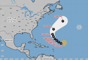 In the tropics, Tropical Storm Gabrielle is battling wind shear and dry air as it makes its way through the central Atlantic. Early Thursday evening, Gabrielle was about 700 miles east-northeast of the northern Leeward Islands and had maximum sustained winds of 50 miles per hour. It was moving west-northwest at 13 miles per hour. TS Gabrielle is forecast to strengthen this weekend as it turns northwestward and then northeastward in the central Atlantic. But it could come close to Bermuda and have some effects there on Sunday and Monday.
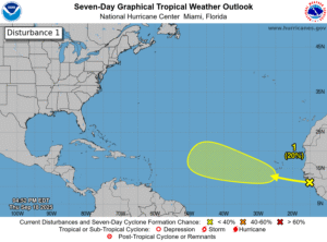 Elsewhere, we’re watching a wave near the African coast. It has a low chance of becoming a depression during the next several days as it moves west-northwestward across the eastern and central Atlantic.
Disclaimer
Artificial Intelligence Disclosure & Legal Disclaimer
AI Content Policy.
To provide our readers with timely and comprehensive coverage, South Florida Reporter uses artificial intelligence (AI) to assist in producing certain articles and visual content.
Articles: AI may be used to assist in research, structural drafting, or data analysis. All AI-assisted text is reviewed and edited by our team to ensure accuracy and adherence to our editorial standards.
Images: Any imagery generated or significantly altered by AI is clearly marked with a disclaimer or watermark to distinguish it from traditional photography or editorial illustrations.
General Disclaimer
The information contained in South Florida Reporter is for general information purposes only.
South Florida Reporter assumes no responsibility for errors or omissions in the contents of the Service. In no event shall South Florida Reporter be liable for any special, direct, indirect, consequential, or incidental damages or any damages whatsoever, whether in an action of contract, negligence or other tort, arising out of or in connection with the use of the Service or the contents of the Service.
The Company reserves the right to make additions, deletions, or modifications to the contents of the Service at any time without prior notice. The Company does not warrant that the Service is free of viruses or other harmful components.


")
")
")


")

