

Thursday features a mix of hot sun and mainly afternoon showers and storms on the mainland. The Keys will experience occasional clouds and showers. A high risk of dangerous rip currents is in place at the Atlantic beaches through Saturday afternoon. Highs on Thursday will be in the low-90s along the coasts and the Keys, while the rest of South Florida will reach the mid-90s. But it will feel about 10 degrees hotter, so stay hydrated and out of the sun.
Friday will bring mostly sunny skies alternating with showers and storms to the mainland, while the Keys will see a mix of sun, clouds, and maybe a shower. Friday’s highs will be in the low-90s right at the coasts and in the Keys, but the rest of South Florida will top out in the mid-90s.
Saturday will feature sun and clouds with periods of showers and storms on the mainland. Look for plenty of clouds and some showers in the Keys. Saturday’s highs will be mostly in the mid-90s in the East Coast metro area and the low-90s along the Gulf Coast and the Keys.
Sunday will see hot sun and a few showers and storms in the morning on the mainland, but more showers and storms will develop in the afternoon. The Keys will see lots of sun. Sunday’s highs will be mostly in the low 90s.

Monday’s forecast calls for a late August mix of sun, showers, and storms on the mainland, while the Keys will see plenty of sun again. Highs on Monday will be mostly in the mid-90s in the East Coast metro area and the low-90s along the Gulf Coast and the Keys.
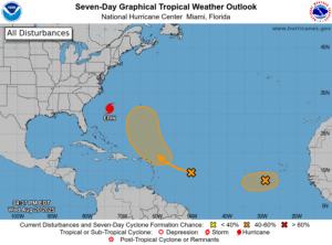 Hurricane Erin is lashing the North Carolina coast with life-threatening storm surge, tropical storm force winds, very rough surf, and potentially deadly rip currents. Dangerous rip currents and rough surf conditions are spreading along the Mid-Atlantic and southern New England coasts.
Late Wednesday afternoon, Erin was about 295 miles south-southeast of Cape Hatteras, North Carolina and 520 miles west of Bermuda. Maximum sustained winds were 110 miles per hour, and Erin was moving north at 14 miles per hour at that time.
There’s a storm surge warning for the North Carolina coast from Cape Lookout to Duck. A tropical storm warning is in effect from Beaufort Inlet, North Carolina to Chincoteague, Virginia, and there’s a tropical storm watch for Bermuda.
Elsewhere in the tropics, we’re watching a wave in the central Atlantic that has a medium chance of becoming a depression in a day or so when it nears the Leeward Islands. After that, this feature is forecast to take a northerly turn and remain in the open ocean. And a wave in the eastern Atlantic also has a medium chance of developing before it reaches an area of unfavorable conditions in a day or so.
Disclaimer
Artificial Intelligence Disclosure & Legal Disclaimer
AI Content Policy.
To provide our readers with timely and comprehensive coverage, South Florida Reporter uses artificial intelligence (AI) to assist in producing certain articles and visual content.
Articles: AI may be used to assist in research, structural drafting, or data analysis. All AI-assisted text is reviewed and edited by our team to ensure accuracy and adherence to our editorial standards.
Images: Any imagery generated or significantly altered by AI is clearly marked with a disclaimer or watermark to distinguish it from traditional photography or editorial illustrations.
General Disclaimer
The information contained in South Florida Reporter is for general information purposes only.
South Florida Reporter assumes no responsibility for errors or omissions in the contents of the Service. In no event shall South Florida Reporter be liable for any special, direct, indirect, consequential, or incidental damages or any damages whatsoever, whether in an action of contract, negligence or other tort, arising out of or in connection with the use of the Service or the contents of the Service.
The Company reserves the right to make additions, deletions, or modifications to the contents of the Service at any time without prior notice. The Company does not warrant that the Service is free of viruses or other harmful components.


")


")