

Saturday features mostly sunny skies and some afternoon showers and storms in the East Coast metro area. The Gulf Coast will see a sunny morning, with some showers and storms developing in the afternoon. Look for a mix of sun and clouds in the Keys. Highs on Saturday will be in the low 90s right at the Atlantic coast and the Keys, while the rest of South Florida will reach the mid 90s — but it will feel about 10 degrees hotter, so stay hydrated and out of the sun.
Sunday will bring plenty of hot sun and some mainly afternoon showers and storms to the mainland, while the Keys will see mostly sunny skies and a stray shower in spots. Sunday’s highs will be in the low-90s.
Monday will feature hot sun, a few morning storms in spots, and plenty of afternoon showers and storms on the mainland. Look for a mix of sun and clouds in the Keys. Monday’s highs will be in the low-90s.
Tuesday will see more of the same: hot sun, a few morning storms, and plenty of afternoon showers and storms on the mainland, while the Keys will be mostly sunny again. Tuesday’s highs will be mostly in the low 90s, with a few suburban locations topping out in the mid-90s.

Wednesday’s forecast calls for a summertime mix of hot sun, showers, and some storms. Highs on Wednesday will be mostly in the low 90s, but some locations will reach the mid 90s.
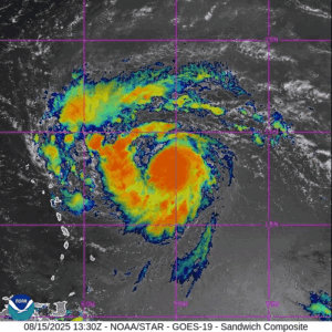 In the tropics, Erin is now a category 2 hurricane and is forecast to intensify quickly this weekend. Late Friday, Erin was located about 365 miles east of the northern Leeward Islands and was moving west-northwest at 17 miles per hour. Maximum sustained winds were 100 miles per hour at that time.
Tropical storm watches are in effect for St. Martin and St. Barthelemy, Saba and St. Eustatius, and Sint Maarten in the northern Leeward Islands. The Virgin Islands and northern Puerto Rico could see heavy rain, high surf, and dangerous rip currents this weekend.
Erin is forecast to turn to the northwest well east of the Bahamas, making its closest approach on Tuesday. We’ll continue to keep a close eye on Erin..
Disclaimer
Artificial Intelligence Disclosure & Legal Disclaimer
AI Content Policy.
To provide our readers with timely and comprehensive coverage, South Florida Reporter uses artificial intelligence (AI) to assist in producing certain articles and visual content.
Articles: AI may be used to assist in research, structural drafting, or data analysis. All AI-assisted text is reviewed and edited by our team to ensure accuracy and adherence to our editorial standards.
Images: Any imagery generated or significantly altered by AI is clearly marked with a disclaimer or watermark to distinguish it from traditional photography or editorial illustrations.
General Disclaimer
The information contained in South Florida Reporter is for general information purposes only.
South Florida Reporter assumes no responsibility for errors or omissions in the contents of the Service. In no event shall South Florida Reporter be liable for any special, direct, indirect, consequential, or incidental damages or any damages whatsoever, whether in an action of contract, negligence or other tort, arising out of or in connection with the use of the Service or the contents of the Service.
The Company reserves the right to make additions, deletions, or modifications to the contents of the Service at any time without prior notice. The Company does not warrant that the Service is free of viruses or other harmful components.


")


")