

Monday features a mix of sun, clouds, and mostly afternoon showers and storms in the east coast metro area. The Gulf coast will see more clouds than sun and periods of showers and storms from late morning into the evening. Look for mostly sunny skies and a few showers in spots in the Keys. Highs on Monday will be in the upper 80s right at the coasts and in the Keys, while suburban locations will reach the low 90s.
Tuesday will bring some sun, more clouds, and periods of showers and storms. Tuesday’s highs will be near 90 degrees in the east coast metro area and in the upper 80s along the Gulf coast and in the Keys.
Wednesday will feature partly sunny skies alternating with periods of showers and storms on the mainland. Look for a mix of sun and clouds with maybe a stray shower in the Keys. Wednesday’s highs will be mostly in the upper 80s.
Thursday will see a mix of sun and clouds, with some showers and storms on the mainland. The Keys will see clouds and showers. Thursday’s highs will be near 90 degrees in the east coast metro area and in the upper 80s along the Gulf coast and in the Keys.

The Independence Day forecast calls for sun, clouds, and periods of showers and storms on the mainland, and the Keys will see clouds and showers. Some showers could linger into the evening, especially in eastern portions of South Florida, so fireworks shows could be affected. Highs on Friday will be near 90 degrees in the east coast metro area and in the upper 80s along the Gulf coast and in the Keys.
 In the tropics, Tropical Depression # 2 became Tropical Storm Barry on Sunday. as it approached the Mexican coast. Barry quickly weakened to a depression on Sunday evening.. The biggest threats from Barry continue to be heavy rains and flash flooding which could last for a couple of days.
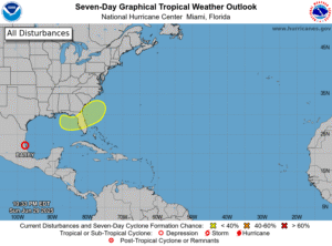
Closer to home, we’re watching a broad area stretching from the Gulf of Mexico, across the Florida peninsula, and into the Atlantic. A frontal boundary is forecast to stall out in that area late this week and drift off the US coast, which could give it time to develop. The National Hurricane Center currently gives this feature a low chance of becoming a subtropical or tropical depression.
Disclaimer
Artificial Intelligence Disclosure & Legal Disclaimer
AI Content Policy.
To provide our readers with timely and comprehensive coverage, South Florida Reporter uses artificial intelligence (AI) to assist in producing certain articles and visual content.
Articles: AI may be used to assist in research, structural drafting, or data analysis. All AI-assisted text is reviewed and edited by our team to ensure accuracy and adherence to our editorial standards.
Images: Any imagery generated or significantly altered by AI is clearly marked with a disclaimer or watermark to distinguish it from traditional photography or editorial illustrations.
General Disclaimer
The information contained in South Florida Reporter is for general information purposes only.
South Florida Reporter assumes no responsibility for errors or omissions in the contents of the Service. In no event shall South Florida Reporter be liable for any special, direct, indirect, consequential, or incidental damages or any damages whatsoever, whether in an action of contract, negligence or other tort, arising out of or in connection with the use of the Service or the contents of the Service.
The Company reserves the right to make additions, deletions, or modifications to the contents of the Service at any time without prior notice. The Company does not warrant that the Service is free of viruses or other harmful components.


")


")