

Saturday features morning lows in the 60s as a front clears South Florida. The day will be sunny, and the east coast metro area will also see a gusty breeze. Expect minor to moderate flooding at high tides in the East Coast metro area and minor flooding at high tides along the Gulf Coast on Saturday into Sunday. The Keys continue to see coastal flooding through the weekend. A high risk of dangerous rip currents remains at the Atlantic beaches through Sunday evening. Highs on Saturday will be in the low 80s.
Sunday will bring good sun and a few clouds to the East Coast metro area and the Keys, while the Gulf Coast will see lots of sun. The gusty breeze continues near the Atlantic coast. Sunday’s highs will be in the low 80s.
Monday will feature a nice mix of sun and clouds around South Florida. Monday’s highs will be in the low 80s in the East Coast metro area and the Keys and the mid 80s along the Gulf Coast.
Tuesday will be mostly sunny throughout South Florida. Tuesday’s highs will be mostly in the mid-80s on the mainland and in the low 80s in the Keys.

Wednesday’s forecast calls for some sun, more clouds, and periods of showers as tropical moisture associated with Sara moves into our area. Highs on Wednesday will be mostly in the mid-80s in the East Coast metro area and in the low 80s along the Gulf Coast and in the Keys.
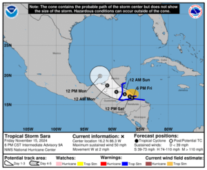 Tropical Storm Sara is moving slowly westward and skirting the coast of Honduras. Heavy rain from this system is already causing flash flooding and mudslides in large portions of Central America. Tropical storm warnings are in effect for the northern coast of Honduras, the Bay Islands, the Caribbean coast of Guatemala, and the coast of Belize. Sara is expected to come ashore in Belize on Sunday and move slowly across the Yucatan, where it is forecast to become a remnant low on Monday. But the remnants of Sara are expected to be swept across the Gulf of Mexico by a front, so Florida is likely to see tropical moisture and periods of heavy rain from this system on Wednesday into Thursday.
Disclaimer
The information contained in South Florida Reporter is for general information purposes only.
The South Florida Reporter assumes no responsibility for errors or omissions in the contents of the Service.
In no event shall the South Florida Reporter be liable for any special, direct, indirect, consequential, or incidental damages or any damages whatsoever, whether in an action of contract, negligence or other tort, arising out of or in connection with the use of the Service or the contents of the Service. The Company reserves the right to make additions, deletions, or modifications to the contents of the Service at any time without prior notice.
The Company does not warrant that the Service is free of viruses or other harmful components
")

")


")

")

