BY ISABELLA O’MALLEY
The National Oceanic and Atmospheric Administration’s Climate Prediction Center says there is a 60% chance that a weak La Nina event will develop this autumn and could last until March.
La Nina is part of a natural climate cycle that can cause extreme weather across the planet — and its effects vary from place to place.
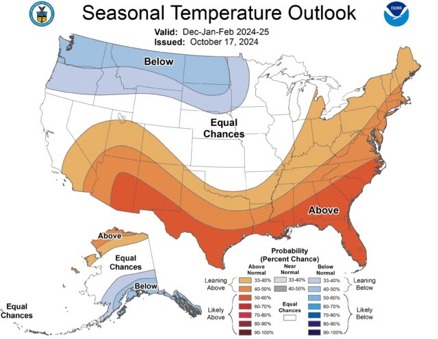
Although there is no guarantee how this La Nina will play out, there are some general trends. Experts say northern parts of South America could see more rain than usual. Southern regions of the U.S. and parts of Mexico could be drier than average. The northern tier of the U.S. and southern Canada could be wetter than average.
La Nina is the cool phase of the El Nino-Southern Oscillation, a naturally occurring global climate pattern that involves changes in wind and ocean temperatures in the Pacific and can cause extreme weather across the planet.
These cold ocean temperatures and changes in the atmosphere affect the position of the jet stream — a narrow band of fast-moving air flowing from west to east around the planet — by bumping it northward. The jet stream sits over the ocean and can tap into its moisture, influence the path storms take and boost precipitation.
Cook noted that the frequency of La Nina events can be stressful for regions that have been dealing with drought lately, such as East Africa. “If we’re moving into another La Nina event, it means kind of a continuation of those really bad conditions.”
La Nina weather impacts
The influence La Nina has on the weather varies based on location and the season, said L’Heureux. Parts of South America, such as eastern Argentina, can be drier than average while Colombia, Venezuela and northern parts of Brazil can be wetter than normal.
“It depends exactly where you are. Part of that is because there’s a monsoon cycle, wet and dry season, that goes through Central America and South America, so La Nina is basically modifying the intensity and placement of those monsoon cycles,” explained L’Heureux.
In the U.S., the Northeast and Ohio Valley typically see wetter than normal conditions with an active storm track due to the position of the jet stream, said Samantha Borisoff, a climate scientist at NOAA’s Northeast Regional Climate Center based at Cornell University.
La Nina, El Nino and climate change
Scientists say the link between climate change and La Nina and El Nino is not entirely clear.
Paul Roundy, climate scientist at the University at Albany, said climate models tend to indicate more frequent El Ninos and less frequent La Ninas, but not all models agree. Computer models also struggle to separate normal variation in the El Nino and La Nina phases from climate change’s warming influence on the oceans and atmosphere.
Disclaimer
Artificial Intelligence Disclosure & Legal Disclaimer
AI Content Policy.
To provide our readers with timely and comprehensive coverage, South Florida Reporter uses artificial intelligence (AI) to assist in producing certain articles and visual content.
Articles: AI may be used to assist in research, structural drafting, or data analysis. All AI-assisted text is reviewed and edited by our team to ensure accuracy and adherence to our editorial standards.
Images: Any imagery generated or significantly altered by AI is clearly marked with a disclaimer or watermark to distinguish it from traditional photography or editorial illustrations.
General Disclaimer
The information contained in South Florida Reporter is for general information purposes only.
South Florida Reporter assumes no responsibility for errors or omissions in the contents of the Service. In no event shall South Florida Reporter be liable for any special, direct, indirect, consequential, or incidental damages or any damages whatsoever, whether in an action of contract, negligence or other tort, arising out of or in connection with the use of the Service or the contents of the Service.
The Company reserves the right to make additions, deletions, or modifications to the contents of the Service at any time without prior notice. The Company does not warrant that the Service is free of viruses or other harmful components.


