

 A tropical storm warning is in effect for all of South Florida, along with a flood watch. There’s also a hurricane watch for the Gulf Coast from Chokoloskee to the Suwannee River and a storm surge warning from Flamingo to the Suwannee River.
This is in addition to other warnings in Florida, including a hurricane warning from Bonita Beach to the Suwannee River on the Gulf coast and from the St. Lucie/Martin county line to Ponte Vedra Beach on the Atlantic coast. There’s also a hurricane watch from the St. Lucie/Martin county line southward to the Martin/Palm Beach county line.
In the Bahamas, there’s a tropical storm warning for Grand Bahama Island, Bimini, and the Abacos, along with a tropical storm watch for the rest of the northwestern Bahamas.
Hurricane Milton is expected to make landfall somewhere in the warning area on the Gulf Coast late Wednesday night and then cut across the Florida peninsula. Conditions will deteriorate there much earlier on Wednesday.

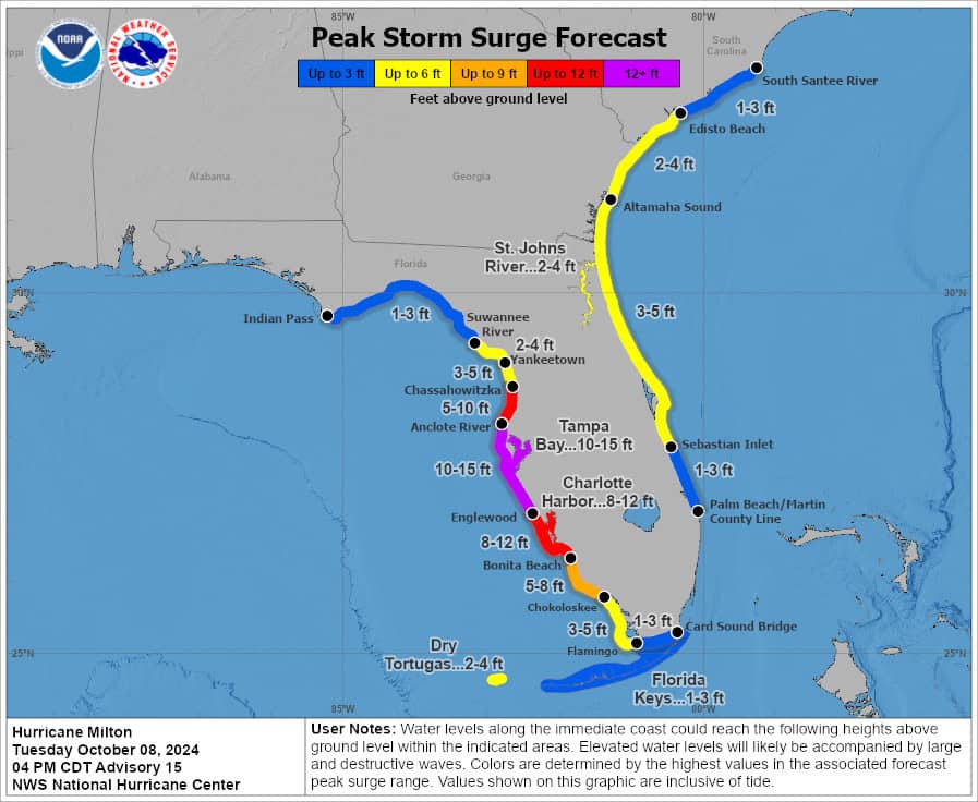
Here in South Florida, Wednesday will see tropical storm conditions and at least hurricane strength gusts along the Gulf coast during the day and throughout the evening. The east coast metro area and the Keys can expect tropical storm force gusts and periods of sustained winds above 39 miles per hour. All of South Florida can expect up to 4 inches of additional rainfall. The Naples area can expect 4 to 7 feet of storm surge, and the Keys could see 1 to 3 feet of coastal flooding. Surf conditions will be extremely hazardous. Highs on Wednesday will be mostly in the upper 80s.
Thursday morning is likely to see the continuation of tropical storm conditions in South Florida. Winds will gradually weaken in the afternoon while clouds will linger. Expect hazardous surf conditions and periods of showers and storms with heavy rain at times. Thursday’s highs will be in the upper 80s.
Friday will feature breezy conditions, mostly sunny skies, and a few passing showers and storms. Friday’s highs will be in the mid-80s.
Saturday will see a mix of sun, clouds, and a few afternoon showers in the east coast metro area. The Gulf Coast will be sunny with a brisk and gusty breeze. Look for clouds and showers in the Keys. Saturday’s highs will be in the mid-80s.
Sunday’s forecast calls for good sun, a few clouds, and a shower or two on the mainland. Look for clouds and showers again in the Keys. Highs on Sunday will be in the mid-80s.
Hurricane Milton is the big story in the tropics, and it could be one of the worst hurricane disasters in Florida history.
But that’s not all that’s happening in the tropical Atlantic. Leslie is still moving northwestward over the central Atlantic, but a turn to the northeast — and some weakening — is expected. An area of low pressure (which brought us our flooding rains earlier in the week) is now northeast of the Bahamas. This feature has a low chance of developing before hostile upper level winds do it in. And that wave that’s been forecast to emerge from the African coast has a low chance of developing, but it will pass over or near the Cabo Verde Islands.
Disclaimer
Artificial Intelligence Disclosure & Legal Disclaimer
AI Content Policy.
To provide our readers with timely and comprehensive coverage, South Florida Reporter uses artificial intelligence (AI) to assist in producing certain articles and visual content.
Articles: AI may be used to assist in research, structural drafting, or data analysis. All AI-assisted text is reviewed and edited by our team to ensure accuracy and adherence to our editorial standards.
Images: Any imagery generated or significantly altered by AI is clearly marked with a disclaimer or watermark to distinguish it from traditional photography or editorial illustrations.
General Disclaimer
The information contained in South Florida Reporter is for general information purposes only.
South Florida Reporter assumes no responsibility for errors or omissions in the contents of the Service. In no event shall South Florida Reporter be liable for any special, direct, indirect, consequential, or incidental damages or any damages whatsoever, whether in an action of contract, negligence or other tort, arising out of or in connection with the use of the Service or the contents of the Service.
The Company reserves the right to make additions, deletions, or modifications to the contents of the Service at any time without prior notice. The Company does not warrant that the Service is free of viruses or other harmful components.


