

Saturday features mostly sunny skies with a few morning storms and some afternoon showers in the east coast metro area. The Gulf Coast will see a mix of sun and clouds with mainly afternoon showers and storms. Look for clouds, showers, and some storms in the Keys. Expect an elevated risk of dangerous rip currents at the Atlantic beaches on Saturday and at least through Sunday. Highs on Saturday will be mostly in the mid-80s, with a few suburban locations reaching the upper 80s.
Sunday will bring heavy rain and the threat of localized flooding. The day will be cloudy, with plenty of showers and some storms that will last into the evening. Sunday’s highs will be in the mid-80s.
Monday will feature lots of clouds with plenty of showers and storms as we feel the effects of a slow-moving tropical disturbance. Heavy rain and localized flooding are likely. Monday’s highs will be in the mid-80s.
Tuesday will be cloudy with morning showers and plenty of afternoon storms. Heavy rain and localized flooding will be a continuing threat. Tuesday’s highs will be in the mid-80s.

Wednesday’s forecast calls for some sun and more clouds with periods of showers and storms. Additional rainfall could result in localized flooding in spots. Highs on Wednesday will be in the mid-80s.
 In the tropics, we will feel the effects of an area of disturbed weather that’s now in the southern Gulf of Mexico during the next several days. A low is expected to form this weekend, and the National Hurricane Center gives this feature a medium chance of becoming a tropical or subtropical depression sometime next week. The setup for development is complicated, as this feature will be affected by a front — and the exact position of that front is uncertain at this time. Regardless of development, all of South Florida should expect periods of heavy rain and potential flooding through the middle of next week.
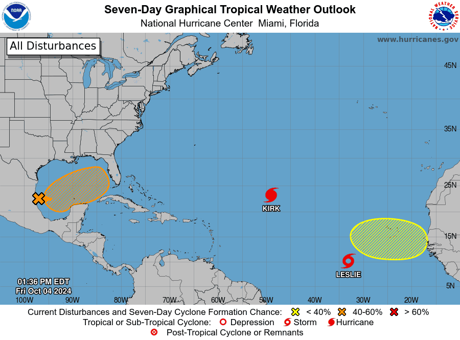 Elsewhere, Kirk has weakened slightly in the central Atlantic, but it remains a powerful hurricane. Kirk is forecast to turn to the northeast and become post-tropical early next week before it reaches the northwestern coast of France and the southern British Isles. Leslie is forecast to become a hurricane in the central Atlantic on Saturday, but it is expected to remain over open waters.
Disclaimer
Artificial Intelligence Disclosure & Legal Disclaimer
AI Content Policy.
To provide our readers with timely and comprehensive coverage, South Florida Reporter uses artificial intelligence (AI) to assist in producing certain articles and visual content.
Articles: AI may be used to assist in research, structural drafting, or data analysis. All AI-assisted text is reviewed and edited by our team to ensure accuracy and adherence to our editorial standards.
Images: Any imagery generated or significantly altered by AI is clearly marked with a disclaimer or watermark to distinguish it from traditional photography or editorial illustrations.
General Disclaimer
The information contained in South Florida Reporter is for general information purposes only.
South Florida Reporter assumes no responsibility for errors or omissions in the contents of the Service. In no event shall South Florida Reporter be liable for any special, direct, indirect, consequential, or incidental damages or any damages whatsoever, whether in an action of contract, negligence or other tort, arising out of or in connection with the use of the Service or the contents of the Service.
The Company reserves the right to make additions, deletions, or modifications to the contents of the Service at any time without prior notice. The Company does not warrant that the Service is free of viruses or other harmful components.


