

Monday features hot sun and some clouds in the morning, followed by periods of showers and storms from the mid-afternoon into the early evening. Expect an elevated risk of dangerous rip currents at the Atlantic beaches. Highs on Monday will be mostly in the mid-90s, with a few inland locations topping out in the upper-90s. But it will feel at least 10 degrees hotter, so stay hydrated and out of the sun.
Tuesday will bring mostly sunny skies and afternoon showers and storms. Look for some storms to move in during the evening hours. Tuesday’s highs will be near 90 degrees in the East Coast metro area and the Keys and in the low 90s along the Gulf Coast.
Wednesday will feature more clouds than sun with plenty of showers and storms that will last into the evening. Wednesday’s highs will be near 90 degrees in the East Coast metro area and in the low 90s along the Gulf Coast.

Thursday will be partly sunny with plenty of showers and storms, with storms around from mid-morning in the East Coast metro area and mid-afternoon along the Gulf Coast. Thursday’s highs will be in the low 90s.
Friday’s forecast calls for plenty of showers and storms with periods of sun. Highs on Friday will be mostly in the low 90s.
 The wave we’ve been tracking for some time became Potential Tropical Cyclone # 6 in the southwestern Gulf of Mexico late Sunday afternoon. While Potential TC # 6 did not have a closed circulation at that time. it had maximum sustained winds of 50 miles per hour — so it is expected to become Tropical Storm Francine soon and probably reach hurricane strength before landfall on the US northern Gulf coast on Wednesday. At 5 pm Sunday, Potential TC # 6 was located about 575 miles south-southeast of Port Arthur, Texas. There is now a tropical storm watch from Barra del Tordo in Mexico to the mouth of the Rio Grande, with additional watches and warnings expected on Monday.
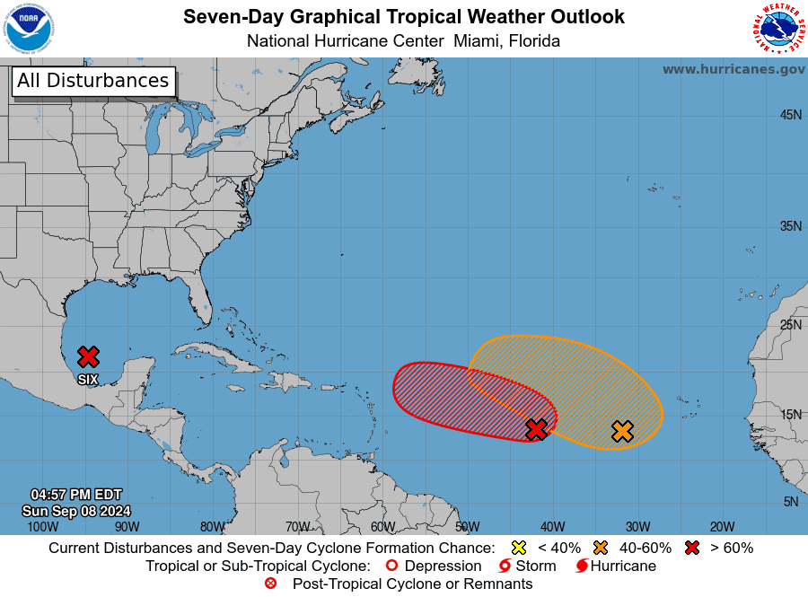 Elsewhere, the area of low pressure in the central Atlantic has a high chance of becoming a depression in the next day or so as it begins to move westward. And the trough of low pressure now several hundred miles southwest of the Cabo Verde Islands has a medium chance of developing as it moves to the west-northwest.
Disclaimer
Artificial Intelligence Disclosure & Legal Disclaimer
AI Content Policy.
To provide our readers with timely and comprehensive coverage, South Florida Reporter uses artificial intelligence (AI) to assist in producing certain articles and visual content.
Articles: AI may be used to assist in research, structural drafting, or data analysis. All AI-assisted text is reviewed and edited by our team to ensure accuracy and adherence to our editorial standards.
Images: Any imagery generated or significantly altered by AI is clearly marked with a disclaimer or watermark to distinguish it from traditional photography or editorial illustrations.
General Disclaimer
The information contained in South Florida Reporter is for general information purposes only.
South Florida Reporter assumes no responsibility for errors or omissions in the contents of the Service. In no event shall South Florida Reporter be liable for any special, direct, indirect, consequential, or incidental damages or any damages whatsoever, whether in an action of contract, negligence or other tort, arising out of or in connection with the use of the Service or the contents of the Service.
The Company reserves the right to make additions, deletions, or modifications to the contents of the Service at any time without prior notice. The Company does not warrant that the Service is free of viruses or other harmful components.


