


Friday features plenty of clouds and periods of showers in the morning, followed by storms in the afternoon and evening. The flood watch remains in effect through Friday evening, as additional rain will cause serious flooding in many areas in which the ground is already saturated. Highs on Friday will be in the mid-80s on the mainland and the upper 80s in the Keys.
Saturday will bring clouds and showers in the morning, giving way to periods of storms in the afternoon and evening. Saturday’s highs will be mostly in the mid-80s.
Father’s Day will feature some sun and more clouds. Look for showers and a few storms throughout the day in the East Coast metro area, while the Gulf Coast will see mostly afternoon and evening showers and storms. Sunday’s highs will be in the upper 80s in the East Coast metro area and the Keys and in the low 90s along the Gulf Coast.

Monday will see a mix of sun and clouds with periods of showers and storms that will begin in the mid afternoon and last into the evening. Monday’s highs will be in the upper 80s in the East Coast metro area and the Keys and in the low 90s along the Gulf Coast.
Tuesday’s forecast calls for a summertime mix of sun, clouds, showers, and storms. Highs on Tuesday will be in the upper 80s in the East Coast metro area and the Keys and in the low 90s along the Gulf Coast.
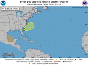 In the tropics, the system that’s bedeviled South Florida’s weather is now off the southeast US coast. The National Hurricane Center gives it a low chance of becoming a depression. We’re also keeping an eye on the Bay of Campeche, where a low is forecast to form this weekend or early next week. The NHC gives this feature a medium chance of becoming a depression before it reaches the Mexican coast.
Disclaimer
Artificial Intelligence Disclosure & Legal Disclaimer
AI Content Policy.
To provide our readers with timely and comprehensive coverage, South Florida Reporter uses artificial intelligence (AI) to assist in producing certain articles and visual content.
Articles: AI may be used to assist in research, structural drafting, or data analysis. All AI-assisted text is reviewed and edited by our team to ensure accuracy and adherence to our editorial standards.
Images: Any imagery generated or significantly altered by AI is clearly marked with a disclaimer or watermark to distinguish it from traditional photography or editorial illustrations.
General Disclaimer
The information contained in South Florida Reporter is for general information purposes only.
South Florida Reporter assumes no responsibility for errors or omissions in the contents of the Service. In no event shall South Florida Reporter be liable for any special, direct, indirect, consequential, or incidental damages or any damages whatsoever, whether in an action of contract, negligence or other tort, arising out of or in connection with the use of the Service or the contents of the Service.
The Company reserves the right to make additions, deletions, or modifications to the contents of the Service at any time without prior notice. The Company does not warrant that the Service is free of viruses or other harmful components.


")


")