

Sunday features some sun, more clouds on a gentle ocean breeze, and dry conditions. Highs on Sunday will be mostly in the mid-80s
Monday will bring another day of seasonable weather. Look for a mix of sun and clouds with an ocean breeze. Monday’s highs will be in the mid-80s in the East Coast metro area and the Keys and in the upper 80s along the Gulf Coast.
Tuesday will feature mostly sunny skies, breezy conditions, and the chance of a stray afternoon shower in the East Coast metro area. The Gulf Coast will see lots of sun with a cloud or two on a gusty breeze. Tuesday’s highs will be in the mid-80s in the East Coast metro area and the Keys and in the upper 80s along the Gulf Coast.
Wednesday will be breezy with plenty of sun and a few clouds. Wednesday’s highs will be in the mid-80s in the East Coast metro area and the Keys and in the upper 80s along the Gulf Coast.

Thursday’s forecast calls for a breezy and sunny late October day. Highs on Thursday will be in the mid-80s in the East Coast metro area and the Keys and in the upper 80s along the Gulf Coast.
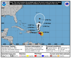 In the tropics, Hurricane Tammy is bringing damaging winds, heavy rain, and storm surge to portions of the Leeward Islands and northern Windward Islands. At midday on Saturday, Tammy’s maximum sustained winds were 85 miles per hour. Tammy will be moving into an area of increasing windshear by the middle of the week. Computer models are not in agreement on just when Tammy will interact with a front on Tuesday or Wednesday — so the track forecast is uncertain. We’ll need to keep an eye on Tammy, just in case it poses any threat to the U.S. East Coast.
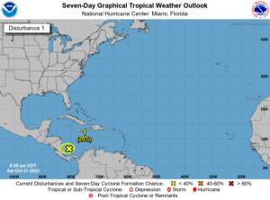 Elsewhere, the area of disturbed weather in the extreme southwestern Caribbean has a low chance of developing before it reaches the coast of Central America on Monday or early Tuesday.
Disclaimer
Artificial Intelligence Disclosure & Legal Disclaimer
AI Content Policy.
To provide our readers with timely and comprehensive coverage, South Florida Reporter uses artificial intelligence (AI) to assist in producing certain articles and visual content.
Articles: AI may be used to assist in research, structural drafting, or data analysis. All AI-assisted text is reviewed and edited by our team to ensure accuracy and adherence to our editorial standards.
Images: Any imagery generated or significantly altered by AI is clearly marked with a disclaimer or watermark to distinguish it from traditional photography or editorial illustrations.
General Disclaimer
The information contained in South Florida Reporter is for general information purposes only.
South Florida Reporter assumes no responsibility for errors or omissions in the contents of the Service. In no event shall South Florida Reporter be liable for any special, direct, indirect, consequential, or incidental damages or any damages whatsoever, whether in an action of contract, negligence or other tort, arising out of or in connection with the use of the Service or the contents of the Service.
The Company reserves the right to make additions, deletions, or modifications to the contents of the Service at any time without prior notice. The Company does not warrant that the Service is free of viruses or other harmful components.


")

")

")
")
")