

 Saturday features lots of clouds and periods of storms in the east coast metro area. The Gulf Coast will see a mix of sun, clouds, and storms. A high risk of dangerous rip currents remains along the Palm Beach County coast, and there’s a moderate rip current risk at the beaches of Miami-Dade and Broward. Highs on Saturday will be mostly in the mid-80s in the East Coast metro area and near 90 degrees along the Gulf Coast and in the Keys.
Sunday will bring some sun, more clouds, and periods of storms, especially in the afternoon and evening. Sunday’s highs will be mostly in the upper 80s.
Monday morning will see a mix of sun, clouds, and showers in the east coast metro area. The Gulf Coast will see some storms in the morning along with sun and clouds. All of South Florida will see periods of storms in the afternoon and evening. Monday’s highs will be near 90 degrees in the East Coast metro area and in the low 90s along the Gulf Coast and in the Keys.
Tuesday will feature morning showers and afternoon storms in the east coast metro area. Look for a mix of sun, clouds, and periods of storms along the Gulf Coast. Tuesday’s highs will be mostly in the upper 80s in the East Coast metro area and in the low 90s along the Gulf Coast and in the Keys.

Wednesday’s forecast calls for mostly sunny skies alternating with periods of showers and storms. Highs on Wednesday will be in the upper 80s in the East Coast metro area and in the low 90s along the Gulf Coast and in the Keys.
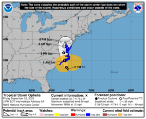 In the tropics, what was Potential Tropical Cyclone # 16 became Tropical Storm Ophelia late Friday morning — and it was already bringing tropical storm conditions to coastal areas of North Carolina. Ophelia is forecast to come ashore in North Carolina on Saturday morning and then essentially follow I-95 into Virginia and Maryland before dissipating on Monday. But it will bring heavy rain and flash floods from North Carolina into New Jersey, as well as storm surge flooding and deadly rip currents along the Mid-Atlantic coast.
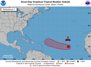 Elsewhere, the wave that’s now in the central Atlantic has a high chance of becoming a depression in a day or so. We’ll keep an eye on it.
Disclaimer
Artificial Intelligence Disclosure & Legal Disclaimer
AI Content Policy.
To provide our readers with timely and comprehensive coverage, South Florida Reporter uses artificial intelligence (AI) to assist in producing certain articles and visual content.
Articles: AI may be used to assist in research, structural drafting, or data analysis. All AI-assisted text is reviewed and edited by our team to ensure accuracy and adherence to our editorial standards.
Images: Any imagery generated or significantly altered by AI is clearly marked with a disclaimer or watermark to distinguish it from traditional photography or editorial illustrations.
General Disclaimer
The information contained in South Florida Reporter is for general information purposes only.
South Florida Reporter assumes no responsibility for errors or omissions in the contents of the Service. In no event shall South Florida Reporter be liable for any special, direct, indirect, consequential, or incidental damages or any damages whatsoever, whether in an action of contract, negligence or other tort, arising out of or in connection with the use of the Service or the contents of the Service.
The Company reserves the right to make additions, deletions, or modifications to the contents of the Service at any time without prior notice. The Company does not warrant that the Service is free of viruses or other harmful components.

")
")


")

")
")
