


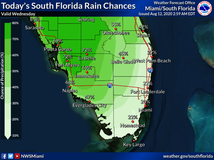
 Wednesday features good sun in the morning with showers and storms in the afternoon, especially along the Gulf Coast and in the interior. Highs on Wednesday will be in the low 90s — but it will feel like the triple digits again.
LIVE RADAR 24/7 (Click Here Then Press Play)
Thursday will start with mostly sunny skies, followed by widespread afternoon showers and storms. Thursday’s highs will be in the low 90s.
Friday will be another day with plenty of sun in the morning and developing showers and storms in the mid to late afternoon. Friday’s highs will be mostly in the low 90s.
Saturday will feature more of the same — good sun in the morning and periods of showers and storms in the afternoon. Saturday’s highs will be in the low 90s.
Sunday’s forecast calls for mostly sunny skies alternating with showers and storms. Highs on Sunday will be in the low 90s again.
 In the tropics, the area of disturbed weather in the central Atlantic is now Tropical Depression # 11. At 5 am Wednesday, TD # 11 was located near 12.2 North, 42.9 West, about 1400 miles east of the northern Leeward Islands. Maximum sustained winds were 35 miles per hour. TD # 11 was moving west at 15 miles per hour. TD # 11 is likely to reach tropical storm status later on Wednesday (with the next name on the list being Josephine). But this system is expected to face strong wind shear that will at least limit its development — and possibly tear it up. We’ll keep an eye on it, because we are entering what is usually the busiest period of the Atlantic hurricane season.


