Home Weather We’re In A Dangerously Hot Weather Pattern

We’re In A Dangerously Hot Weather Pattern

dangerously hot

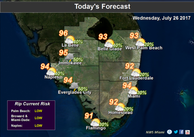
dangerously hotSouth Florida will be dangerously hot on Wednesday, with oppressive conditions around the area. After a muggy start, Wednesday will bring hot sun, building clouds, and developing showers and storms along a weak sea breeze. Periods of heavy rain are possible with slow-moving showers and storms. Highs on Wednesday will be in the low to mid 90s, but it will feel at least 10 degrees hotter. A heat advisory is in place for Miami-Dade, but everyone in the region should be careful to stay hydrated and out of the sun.

Thursday will feature passing showers and storms alternating with hot sun. Highs on Thursday will be in the sticky low to mid 90s.

Friday will bring more of the same — passing showers and storms, hot sun, and oppressive humidity. Friday’s highs will be in the low to mid 90s.

The weather pattern continues into the weekend, with hot sun and passing showers and storms on Saturday. Saturday’s highs will be in the mid 90s, with readings in the upper 90s in some inland locations.

Sunday’s forecast is a repeat — hot sun, some showers and storms, and highs in the mid to upper 90s.

Donna Thomas has studied hurricanes for two decades. She holds a PhD in history when her experience with Hurricane Andrew ultimately led her to earn a degree in broadcast meteorology from Mississippi State University. Donna spent 15 years at WFOR-TV (CBS4 in Miami-Fort Lauderdale), where she worked as a weather producer with hurricane experts Bryan Norcross and David Bernard. She also produced hurricane specials and weather-related features and news coverage, as well as serving as pool TV producer at the National Hurricane Center during the 2004 and 2005 seasons. Donna also served as a researcher on NOAA's Atlantic Hurricane Database Reanalysis Project. Donna specializes in Florida's hurricane history.